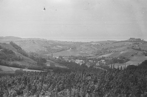
Csáford, Zala, A község látképe
| Collection | Göcseji Múzeum gyűjteményei |
| Inventory number | 5249 |
| Title | A község látképe |
| Author | Dr. Szentmihályi Imre |
| Type | Fotó |
| Description | Délkeletről, az alsóhegyi Verga-dombról nézve. Háttérben a Felsőhegy. |
| Date | 1966.06 |
| Place |
Csáford
Zala |
| Keywords | Néprajzi fotótár; Néprajz; Földrajz; |
| Other fields |
Méret: 2,4 x 3,6 és 6 x 9 cm |
| Automatic keywords | természet; nature; szabadban; outdoors; növény; plant; fa; tree; fenyő; abies; fenyő; fir; növényzet; vegetation; vidék; countryside; tájkép; landscape; lejtő; slope; föld; land; erdőterület; woodland; erdő; forest; hegy; mountain; vidéki; rural; épület; building; táj, látvány; scenery; fennsík; plateau; liget; grove; tűlevelű; conifer; hegység; mountain range; fenyő; pine; légi felvétel; aerial view; szabadidős tevékenységek; leisure activities; kaland; adventure; madár; bird; állat; animal; repülő; flying; |
| Images |
|
No user provided keywords
No comments